Bug Fire Burns 15,000 Acres North of Reno
Evacuation zones keep expanding as the fire pushes toward Hungry Valley.
7 min read

A photo of the still-active Bug Fire taken on Saturday Evening.
Truckee Meadows Fire Protection District
COLD SPRINGS — A wildfire that began Saturday afternoon along United States Route 395 near the Sierra County line had burned an estimated 15,000 acres by late Sunday and was 3 percent contained, according to CAL FIRE. The Bug Fire crossed into Washoe County, Nevada, within hours and has burned in Lassen, Sierra, and Washoe counties. Early Monday, it turned south toward the Reno-Sparks Indian Colony’s Hungry Valley community, which was ordered to evacuate at 6:48 AM. No structures have been reported damaged or destroyed, and no injuries have been reported.
The interagency dispatch log for the Sierra Front area puts the incident at 3:30 PM Saturday at Route 395 north and Bringman Road. Watch Duty logged the same time, when resources were responding to a reported vegetation fire and smoke was visible on the Chilcoot ALERTCalifornia camera. Six minutes later, a unit at the scene put the fire at roughly 10 to 20 acres and moving east. It reached 50 acres before 4 PM, according to the WildCAD dispatch system, and had been named the Bug Fire. CAL FIRE places the origin east of Route 395 and south of Bringman Road in Lassen County, just north of Hallelujah Junction and the Sierra County line, and the Bureau of Land Management’s Carson City District has jurisdiction. The cause remains under investigation.
California evacuations began almost immediately. An evacuation warning was issued for Lassen County zone LAS-671-B before 4 PM, and within about 20 minutes that zone was under an evacuation order with a warning added for LAS-671-A. Sierra County followed minutes later with a warning for zone SIE-E025.
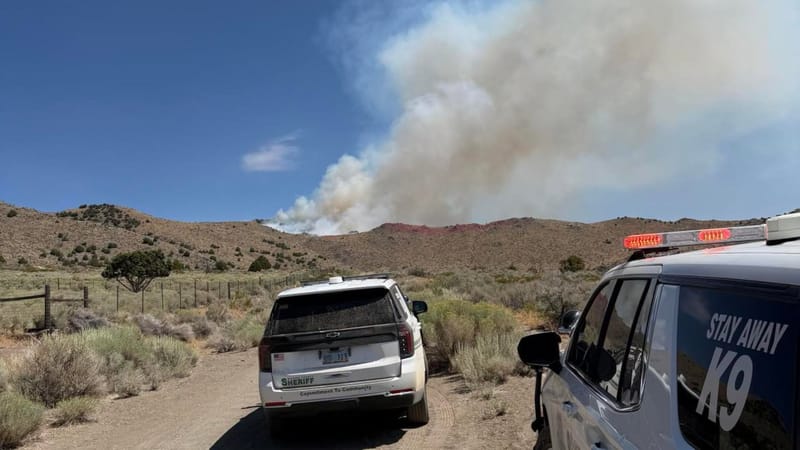
The Washoe County Sheriff’s Department responds to the Bug Fire.
Washoe County Sheriff’s Department
The fire pushed east into Nevada through the evening. Washoe County issued evacuation warnings in Cold Springs and then orders for areas north of Cold Springs before 5 PM. CAL FIRE reported 800 acres around 6 PM. FIRIS mapping flights measured the fire at 2,467 acres at around 6:30 PM, then 4,182 acres just after 7 PM, when CAL FIRE reported the fire was threatening the community of Cold Springs.
Orders widened repeatedly after dark. Washoe County added orders north of Cold Springs and then north of Silver Knolls during the 7 PM hour, and extended orders and warnings around Silver Knolls and the Reno-Stead Airport before 10 PM. A night helicopter coordinator and two night water-dropping helicopters were en route by about 9 PM, according to radio traffic reported by Watch Duty. The county evacuation center was moved to the Evelyn Mount Community Center at 1301 Valley Road in Reno around the same time.
The fire reached a significant road that night. It was approaching Red Rock Road near Adobe Drive and Lemmon Drive by about 9:15 PM, and it had jumped the road in the area of the Buddhist Temple within the next half hour, both according to radio traffic reported by Watch Duty.
The California side quieted as Nevada’s worsened. Fire activity had moderated in Lassen and Sierra counties by late Saturday evening while the fire continued to burn actively in Washoe County, the Sierra County Sheriff’s Office said, adding that crews were continuing suppression work and that the office was monitoring the fire. In Lassen County, the order for LAS-671-B had already been reduced to a warning, and the warning for LAS-671-A was lifted. A FIRIS flight mapped the fire at 6,528 acres before midnight.
Sunday brought steadily expanding zones on the Nevada side. Warnings east of Matterhorn Boulevard were updated in the morning, orders were expanded before noon, and warnings grew again in the early afternoon to take in the area of Matterhorn Boulevard and Argonaught Way. More orders and warnings followed by midafternoon.
Then came a turn that did not hold. In a midafternoon update Sunday, the Truckee Meadows Fire Protection District reported the fire at 20 percent containment and about 6,500 acres, saying crews had made great progress. Evacuations were lifted for the Cold Springs neighborhood, all previously evacuated neighborhoods off White Lake and Village Parkway reopened, and every closed northbound offramp on Route 395 was reopened. About 3,800 households had evacuated at that point, according to Washoe County.
Within hours, the numbers moved the other way. Washoe County issued more orders and warnings on the east side. CAL FIRE put the fire at 7,500 acres by early evening and 11,405 acres by about 6:30 PM, around the time Sierra County’s warning for SIE-E025 was lifted. Zones widened again on the south and east sides. By late Sunday evening, the fire was listed at 15,000 acres and still 3 percent contained.
The fire was moving into developed ground as those figures climbed. Watch Duty’s Cole Euken reported just after 7 PM, from radio traffic, that the fire was cresting above Matterhorn Boulevard and that units were working evacuations on Matterhorn from Argonaught Way to Oregon Boulevard. A new perimeter was uploaded to the National Interagency Fire Center shortly afterward.
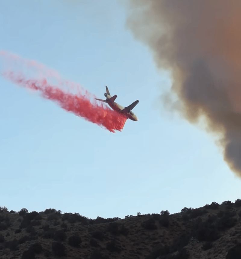
An air tanker drops fire retardant on Sunday.
Washoe County Sheriff’s Department
By early Monday, the fire had turned toward Hungry Valley. Watch Duty reported at about 3:30 AM, citing radio traffic, that the fire was pushing south and was a couple of miles away. The Reno-Sparks Indian Colony issued its order at 6:48 AM, telling Hungry Valley residents to leave immediately, follow directions from Tribal Police and emergency personnel, avoid traveling toward the fire or blocking evacuation routes, and monitor colony alerts. An evacuation center for Hungry Valley residents only opened at the Reno Gym, 34 Reservation Road, and residents needing transportation, medical, or mobility assistance were given the numbers 775-842-2902 and 775-895-9835.
The response has drawn crews from both states. The dispatch log lists assigned resources including two air tankers, an air attack aircraft, a helicopter, engines and battalion chiefs from the Carson City District, a Nevada Division of Forestry unit, and a hand crew. The Truckee Meadows Fire Protection District said firefighters worked through the night from the ground and with air drops to protect structures. Carson City Fire Department Chief Kevin Nyberg confirmed his crews were sent to the fire, and firefighters from Douglas and Lyon counties also responded. The Nevada Army National Guard activated air crews and personnel with two firefighting-equipped helicopters, a CH-47 Chinook and a UH-60 Black Hawk, for aerial suppression.
The Washoe County Sheriff’s Office has assisted crews throughout the Cold Springs and Red Rock areas and asked evacuated residents not to return until officials determine it is safe. “We understand residents are anxious to return home, and we appreciate our community’s patience and cooperation as crews continue working to protect lives, homes, and property,” the office said. It described the fire as active and unpredictable even when flames were less visible than they had been overnight.
The Nevada Highway Patrol closed the White Lake and Village Parkway exits on northbound Route 395 on Saturday, and both reopened Sunday afternoon. Red Rock Road between Moya Boulevard and American Flat Road and Lemmon Drive at Ramsey Way remained closed into Monday, with officials planning to reevaluate. Roughly 2,000 customers in the north valleys lost power after NV Energy shut off equipment near the flames to prevent new starts and protect firefighters, with restoration estimated by 8 PM.
The Washoe County School District canceled classes and activities Monday at eight schools, citing evacuation zones, power outages, and updated information: Desert Heights Elementary School, Silver Lake Elementary School, Lemmon Valley Elementary School, Shaw Middle School, Spanish Springs High School, Alyce Taylor Elementary School, Jesse Hall Elementary School, and Spanish Springs Elementary School. All other district schools were in session.
The evacuation center at the Evelyn Mount Community Center sheltered nearly 70 residents Saturday night, with others staying outside in the parking lot. A trailer for small animals was set up there, and Washoe County Regional Animal Services was taking small animals at its shelter at 2825 Longley Lane. More than 150 animals were being kept at the large-animal shelter at the Reno-Sparks Livestock Events Center, 1350 North Wells Avenue, entered through Gate 2, where officials said space and resources are limited.
The Truckee Meadows Fire Protection District told residents in yellow “Get Set” zones to make arrangements now for their animals, saying Animal Services cannot accept animals from those zones and that residents should plan with family, friends, or boarding facilities before a “Go” order is issued. Several hotels, including Grand Sierra Resort, the Peppermill, and the downtown Row properties, offered reduced rates to those affected, waiving resort fees with proof of residency.
A second fire is burning nearby. The Fred Mountain Fire, off Red Rock Road northeast of the Bug Fire, had burned an estimated 1,393 acres and was 2 percent contained, with Truckee Meadows Fire Protection District crews assigned. Its evacuation zones overlap with the Bug Fire’s.
Northern Nevada Public Health said it is monitoring air quality in the Reno-Sparks area, which was in the good to moderate range for most of Washoe County. Areas closest to and downwind of the fire may reach levels unhealthy for sensitive groups or worse at times. Officials asked residents to call 911 only for new emergencies and to dial 311 for Washoe311 information.