Floriston Fire Reaches 75% Containment as Mop-Up Continues
Drones pinpoint hot spots; highway and forest restrictions remain.
3 min read
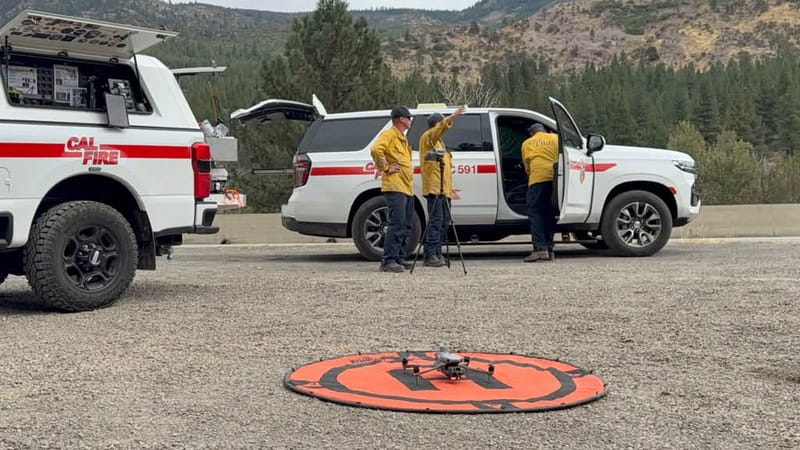
A drone and fire personnel at the Floriston Fire. Infrared drone imagery helped crews locate remaining hot spots in difficult terrain.
FLORISTON — Firefighters are mopping up the Floriston Fire northeast of Truckee on Monday, September 21, after holding the blaze to 622 acres and bringing containment to 75%. Crews are working 300 feet or more inside the perimeter to extinguish remaining hot spots and strengthen containment lines, the California Department of Forestry and Fire Protection reported.
All mandatory evacuation orders had been lifted, with one Nevada County zone still under a warning. Westbound Interstate 80 remained limited to one lane through the fire area. Cal Fire said Monday morning that it expected no further growth.
The fire began at 10:01 AM Wednesday, September 16, near Interstate 80 and Floriston Way, about nine miles northeast of Truckee. Cal Fire is investigating the cause.
Within little more than an hour, the agency estimated the fire at 20 acres and reported a dangerous rate of spread threatening the highway, the Truckee watershed, and nearby natural resources. Wind pushed the fire east on the western side of the highway, and firefighters reported long-range spotting — embers starting fires ahead of the main blaze.
YubaNet’s incident chronology described the fire running uphill into shrubs, vegetation beneath pines, downed vegetation, and white fir. Cal Fire’s estimate reached 613 acres Wednesday evening and 640 acres Thursday. More precise mapping Friday revised the acreage to 622.
The terrain shaped both the firefight and the disruption on Interstate 80. Crews faced steep, rocky slopes that made access difficult, while falling rocks and material rolling downhill threatened the westbound lanes.
By Thursday morning, bulldozers had cut containment lines along portions of the south side, and hand crews had cleared lines around other parts of the fire. Two spot fires had been identified to the north. Cal Fire made the northern side a priority because sections of line remained open or needed strengthening, with down-canyon winds expected through Friday.
Helicopters and air tankers supported crews on the ground, and night-flying helicopters worked the incident Wednesday evening. A Union Pacific fire train brought another water source close to the fire: Cal Fire reported that the train carried 100,000 gallons for firefighting operations.
As the fire’s spread slowed, drones equipped with infrared technology helped locate remaining heat in areas difficult to reach. By Saturday evening, Cal Fire reported that crews had cleared lines by hand around all spot fires and were extinguishing hot spots 200 to 500 feet inside the perimeter. That mop-up work continued into Monday.
The response brought together Cal Fire’s Nevada-Yuba-Placer Unit, the United States Forest Service’s Tahoe and Humboldt-Toiyabe national forests, the California Highway Patrol, and the Nevada and Sierra county sheriff’s offices. The Sacramento Regional Incident Management Team took command at 7 AM Thursday. Caltrans worked with fire personnel to assess the highway and restore westbound travel.
The fire prompted evacuation warnings in both Nevada and Sierra counties and a mandatory order for Nevada County zone NCO-E379-A. On Friday, officials reduced that order to a warning and returned Sierra County zones SIE-E099 and SIE-E100-B to normal status. NCO-E379-A remained the only warning zone Monday morning.
Cal Fire reported no injuries as of Sunday evening, and no structures are reported to have been destroyed. Smoke affected the wider region, with the Northern Nevada Public Health issuing a Reno-Sparks air-quality advisory September 16 because of smoke from the Floriston and Dome fires.
The fire closed westbound Interstate 80 at the Nevada state line Wednesday. One westbound lane reopened Friday morning. In its Sunday evening update, Cal Fire said travel remained restricted to a single lane from Mystic to Floriston Way because of firefighting traffic. Motorists can check Caltrans QuickMap for changing conditions.
Recreation access also remains restricted. A Tahoe National Forest closure order covers national forest lands, roads, and trails generally east of Boca Reservoir between Interstate 80 and Stampede Meadows Road to the forest boundary. The closure includes Boca Springs Campground and took effect Friday, September 18. The order is tentatively scheduled to run through December 31.