Sierra County’s Flood Map Update Is on Hold
Nearly all of Loyalton would fall in FEMA’s high-risk zone, and more homeowners could need flood insurance to meet their mortgage terms.
3 min read
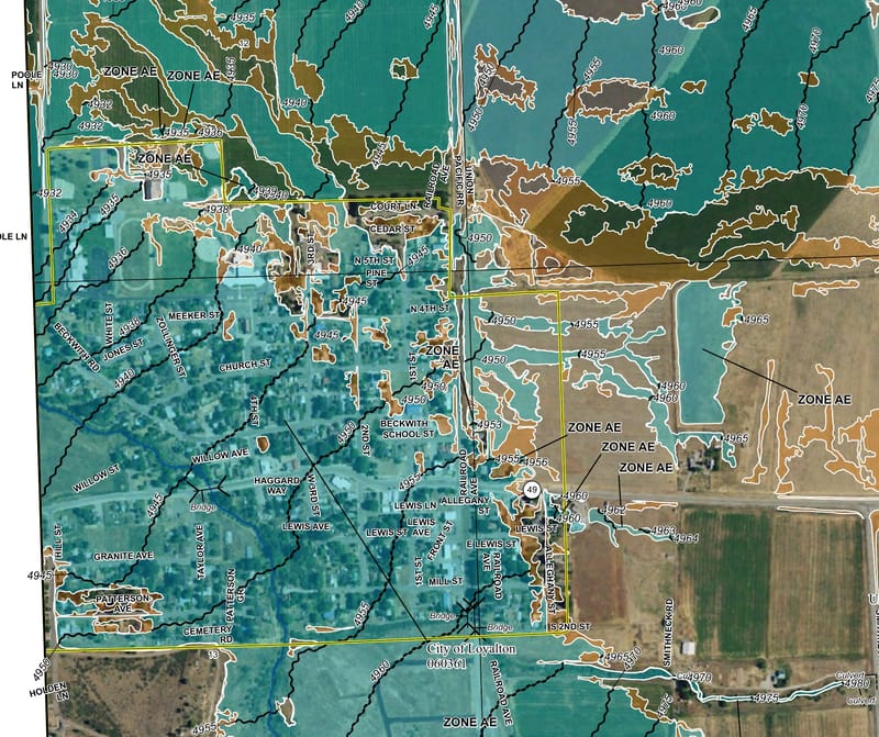
Blue-green shading on FEMA’s October 2025 preliminary map shows where water could reach in a 100-year flood. The yellow line marks Loyalton’s city limits.
Federal Emergency Management Agency
LOYALTON – Proposed federal flood maps that would put nearly all of Loyalton in a high-risk flood zone are on hold, Sierra County Planning Director Brandon Pangman told the Board of Supervisors on November 17. The county had expected November 5 to be the last day to challenge the maps for eastern Sierra County. Pangman said the 90-day appeal period had yet to begin.
In July, Pangman said, the Federal Emergency Management Agency (FEMA) told the county to expect a letter and public notices. When a Sierra Brooks resident expressed interest in filing an appeal, Pangman went back to FEMA to check the deadline and filing requirements. “It became more and more disconcerting as time wore on,” he said of the two weeks he spent waiting for an answer.
A FEMA employee eventually told him the agency had run into problems and was taking another look at the project. The letter and notices never went out, Pangman said, and he was still waiting for a new schedule. In a letter to Sierra County last year, FEMA explained that the second notice in a local newspaper starts the 90-day clock.
On the Plumas County side of Sierra Valley, the same study reached the appeal stage this summer. FEMA’s June 11 notice in the Federal Register identified unincorporated Plumas County, and The Mountain Messenger printed FEMA’s notice for Plumas County on July 30 and August 6. Plumas County Public Works lists August 7 through November 5 as its appeal period.
FEMA’s earlier maps drew an ever-larger floodplain around Loyalton. In February 2022, the Loyalton City Council approved $30,000 for Farr West Engineering to review the maps. The firm and the county engineer identified problems with how FEMA’s models predicted where floodwater would go in Loyalton, Sierraville, and Sierra Brooks. After an April meeting with FEMA, Sierra County’s planning director at the time, Tim Beals, told supervisors the agency had agreed to reexamine the assumptions behind those predictions.
FEMA used ground surveys and airborne laser measurements to draw the revised maps it released in October 2025. The proposed high-risk zone shows where water could reach in a 100-year flood. A flood that large or larger has a 1 percent chance of occurring in any given year. In that scenario, Pangman told supervisors, water would reach nearly all of Loyalton and would be shallow across much of town. Most of Sierraville would stay in the mapped floodplain, while several parcels in Sierra Brooks would come out.
For a homeowner with a mortgage, the maps could determine insurance requirements. If any part of the house is in the high-risk zone on the map in force, a borrower with a federally backed mortgage or a loan from a federally regulated or insured lender must carry flood insurance. If only a corner of the yard is in the zone, the bank can decide whether to require coverage. For an existing mortgage on a house newly mapped into the zone, the requirement begins the day the revised map takes effect. Until then, the current map governs.
The boundaries also help determine where new homes and substantial improvements must meet flood-resistant building standards. Residents can look up an address in FEMA’s Flood Map Changes Viewer or call the Sierra County Planning Department at 530-289-3251 for help finding a property on the preliminary maps.