Winter Storm Warning Issued for Northern Sierra
Rain and strong winds arrive Friday, with heavy snow at higher elevations.
4 min read
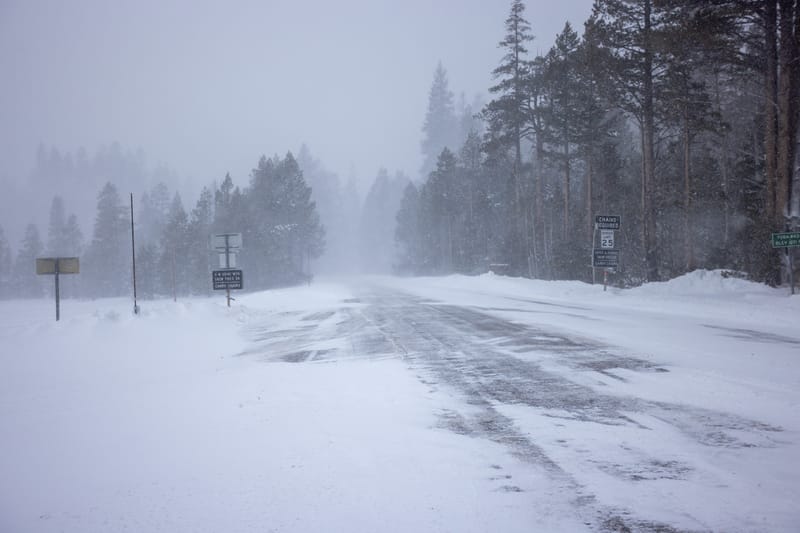
Near-whiteout conditions at the Yuba Pass during a winter storm in 2024.
Staff Photo
LOST SIERRA – A Pacific storm arriving Friday, November 13, is expected to bring heavy mountain snow, soaking rain, and strong winds to the northern Sierra, prompting a winter storm warning and the prospect of difficult travel as the weekend begins.
The National Weather Service’s warning runs from 10 AM Friday to 10 AM Saturday, November 14. Its Thursday midday forecast calls for 6 to 12 inches of snow above 6,000 feet in the northern Sierra, with up to 18 inches on the highest peaks and gusts reaching 60 mph.
Snow levels are expected to start at 6,500 to 7,500 feet Friday, then fall to 5,500 to 6,000 feet Saturday morning. The heaviest snow is forecast from late Friday morning into the overnight hours, affecting higher routes including Interstate 80 and Highway 50. Flurries to 2 inches are possible down to 5,000 feet.
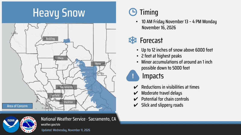
This snowfall outlook, updated November 11, covers 10 AM Friday, November 13, through 4 PM Monday, November 16. The northern Sierra winter storm warning discussed in the article runs from 10 AM Friday through 10 AM Saturday.
National Weather Service Sacramento
The storm opens a series of Pacific systems expected into next week. In his November 11 Weather West analysis, Daniel Swain, a climate scientist with University of California Agriculture and Natural Resources, described successive storms associated with cold fronts, bringing periods of rain, gusty winds, and Sierra snowfall. The weather service also forecasts a chance of thunderstorms Friday in the foothills.
Lower communities face a wet start to the weekend. Thursday afternoon weather service forecasts call for 1 to 2 inches of rain Friday daytime near Downieville and Quincy. Quincy could see rain mix with snow early Saturday, with little or no accumulation. Forecasts for Portola and Sierraville also call for rain changing to a mix Friday afternoon and night, with little or no snow accumulation.
Wind is a concern on the east side. A separate wind advisory covers eastern Plumas and eastern Sierra counties from 10 AM to 10 PM Friday, including Portola, Loyalton, and Sierraville. South to southwest winds of 20 to 30 mph could gust to 55 mph, blowing loose objects, breaking tree limbs, and causing power outages.
Farther south, forecaster Bryan Allegretto’s November 11 outlook for Palisades Tahoe put Friday’s storm at 14 to 20 inches on the resort’s upper mountain by Saturday. His forecast also emphasized colder air arriving as the storm progresses, lowering the elevation where rain turns to snow.
The weather service expects a lull Saturday afternoon through much of Sunday, followed by more rain and mountain snow Sunday night into Monday. Local forecasts show rain chances returning during Sunday, with more widespread precipitation overnight. The Reno forecast office advises considering a delay in Sierra travel until the first storm has passed; road impacts may linger into late Saturday morning.
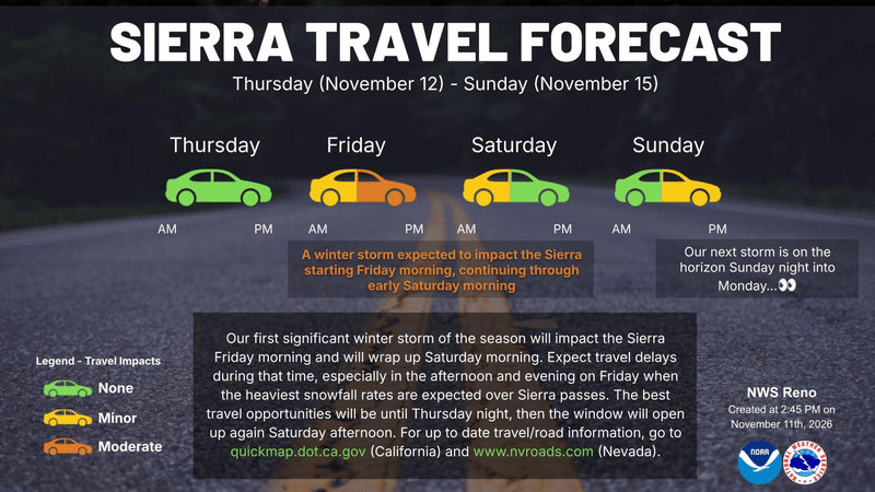
The Sierra travel forecast issued November 11 highlights Friday afternoon and evening as the most difficult travel period, with conditions expected to improve Saturday afternoon before another storm Sunday night into Monday.
National Weather Service Reno
Local agencies have spent the fall preparing for winter. Lori Pini, manager of the Plumas County Office of Emergency Services, told The Mountain Messenger this week that her office’s surveys covered fire departments’ sand and sandbag needs and community services district operations during severe weather and outages. A preparation meeting drew 34 people from 24 partner agencies.
In September reporting by The Mountain Messenger, Sierra County Public Works Director Josh Handel said crews had been clearing culverts and ditches for months and would prioritize main routes for first-responder access. Caltrans District 2 spokesman Chris Woodward described preparations including drainage work, inspections of Highway 70 slopes and tunnels, and readying snow-removal equipment and additional plowing staff.
For households, Plumas County’s November 10 release recommends supplies for at least 72 hours and consideration of a week or longer because rural communities can face extended outages and road disruptions. Sierra County emergency services coordinator LeTina Vanetti recommended 7 to 10 days of food, water, medications, and pet supplies.
Plumas County urges residents to clear gutters and drainage areas, secure loose outdoor items, charge phones and backup batteries, and check on neighbors who may need help or rely on powered medical equipment. They also suggest keeping food that can be prepared without electricity, flashlights, and warm clothing ready.
Portable generators should run outdoors at least 20 feet from homes and buildings, with exhaust directed away from windows, doors, and vents, according to the United States Consumer Product Safety Commission. The county warns against using outdoor heating equipment indoors.
Sierra County also shared state preparedness guidance November 10. The Listos California guide urges people to check flood exposure at home and work, including risks below recent wildfire areas, and to turn around at flooded roads.
Before travelling, check Caltrans QuickMap for closures and chain controls. Plumas County advises carrying tire chains and knowing how to install them, keeping vehicles fueled, packing blankets, food, and water, and avoiding unnecessary travel during severe weather.
Residents can sign up for Plumas County’s Genasys alerts or Sierra County’s Everbridge notifications. Plumas residents should confirm that their registration includes the correct home address and phone number.